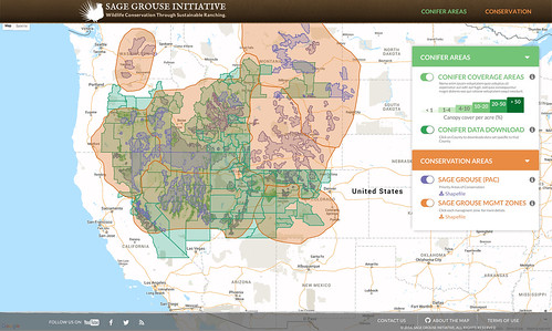
The SGI Interactive Web Application enables conservationists to help plan the best conservation efforts to restore sage grouse habitat. (Click to enlarge)
The saying “The whole is greater than the sum of its parts” is often attributed to the Greek philosopher Aristotle, and that couldn’t be more true when it comes to doing conservation planning across 11 states, multiple federal agencies and millions of acres of public and private land.
The Sage Grouse Initiative (SGI), led by USDA’s Natural Resources Conservation Service (NRCS), introduces the SGI Interactive Web Application, a tool that will take habitat restoration efforts for sage grouse to new heights — both visually and on the ground. The tool graphically layers vital pieces of information to paint a more cohesive picture of connected landscapes, so state and federal agencies and their partners can make more effective and targeted decisions.
For instance, the web application includes a brand new high-resolution map of conifer encroachment across 100 million acres of sagebrush-steppe landscape. Invading conifers degrade the sagebrush landscape by crowding out native plants, that’s why NRCS and its partners target their removal when they’re young.
Conifers are just one layer. Each layer added will help address threats that NRCS is prioritizing through the Sage Grouse Initiative 2.0 investment strategy, a four-year $211 million effort to help conserve sagebrush habitats in 11 Western states. A second layer available depicts the ecosystem’s resilience and resistance based on underlying soil temperature and moisture,” said Jeremy Maestas, NRCS regional biologist.
“Someone using the application will be able to visualize which areas are more or less likely to rebound after wildfire and resist cheatgrass invasion,” Maestas said. “By putting these cutting-edge products at the fingertips of practitioners and landowners, it helps us more quickly apply science and technology into targeted action on the ground.”
The SGI partnership is in the process of adding more layers to the web application and layers will be periodically updated to reflect the most recent scientific information.
Brady Allred, a rangeland specialist with University of Montana, developed the tool for SGI using Google Earth Engine, a platform for petabyte-scale scientific analysis and visualization of geospatial datasets, both for public benefit and for business and government users.
“By using Google Earth Engine, we are able to do range-wide science and conservation planning that was functionally impossible before,” Allred said. “And because Google Earth Engine is built for the web, we can immediately implement that science into planning and decision making.”
Soon the web application will be completely interactive, allowing the user to change analysis parameters, input new data, or specify an area of particular interest for a more detailed analysis. It gives the user the ability to get the exact information he or she needs.
“Geography is not a barrier here,” Allred said. “By focusing on the entire western half of the country, we are able to get the whole picture—a better view of what is occurring. This improves conservation planning for all western rangelands.”
Since 2010, NRCS has worked with ranchers to restore and protect more than 5 million acres of sage grouse habitat through SGI. This work was part of a large landscape-level effort that led the U.S. Fish and Wildlife Service to conclude last year that the sage grouse did not warrant protection under the Endangered Species Act.
Learn more about NRCS’ conservation efforts for sage grouse. For more on technical and financial assistance available through conservation programs, visit www.nrcs.usda.gov/GetStarted.
No comments:
Post a Comment
Note: Only a member of this blog may post a comment.