Search This Blog

Monday, February 29, 2016

Happy Leap Day!

From National Ocean Service:


We're leaping for joy! Happy #LeapDay! Why not take a few moments of your extra 24 hours to explore our ocean and coasts: http://oceanservice.noaa.gov/ 

Image credit: Robert Schwemmer, NOAA National Marine Sanctuaries

Red Fox Leaping for Leap Day!

From the U.S. Fish and Wildlife Service:


Leaping for #LeapDay!
...well, really just for a snack...

This red fox was photographed at Bombay Hook National Wildlife Refuge in Delaware.

Solitary and Territorial Bobcats

February 29, 2016

From U.S. Fish and Wildlife Service Midwest Region:


Even though bobcats are mostly solitary and territorial, they cross ranges in February and March, the height of their mating period.

Photo: Bobcat courtesy of Outward_bound/Creative Commons. https://flic.kr/p/qMo1YX

Leap Day

From the U.S. Geological Survey (USGS):


Leap Day— It's Leap Day...why don't we take a leap and share this photo of an Ornate Horned Frog? Get it? Leap...Frog...Leap Day? OK, enough with our cheesy jokes. This is a photo of an Ornate Horned Frog which are commonly found in parts of South America and are from the Ceratophryidae family. 

Amphibians play important roles in ecosystems. Frogs, toads, and salamanders contribute to ecosystem function by eating small insects and bugs (like mosquitos) and by being a food source to larger animals. Amphibian health can help us evaluate the overall health of the ecosystem. Unfortunately, USGS scientists, and their scientific partners, have found that amphibian populations are declining across the United States. In a first-of-its-kind study, USGS scientists analyzed nine years of data from 34 sites and 48 species. This study concluded that amphibian decline may be more widespread and severe than previously thought. You can learn more about the amphibian research that USGS does and why this kind of research matters at at http://www.usgs.gov/ecosystems/wildlife/amphibians.html. Photo by: Yolanda Fong-Sam, USGS.

#USGS #science #frogs #amphibians #leapday#leapyear #biology #ecosystems

Happy Leap Day!

From the USFWS National Wildlife Refuge System:


Happy Leap Day! In honor of leap year and 2016’s extra day, we present a chum salmon in Cold Bay, Alaska, near Izembek National Wildlife Refuge (http://1.usa.gov/1OaODPG). Photo by Katrina Mueller / U.S. Fish and Wildlife Service

Sunday, February 28, 2016

Sharp-shinned Hawk

From U.S. Fish and Wildlife Service Midwest Region:


Sharp-shinned hawks are small but fierce. Most of their diet is made up of songbirds, but they’ll even go after shorebirds, woodpeckers and falcons!

Photo: Sharp-shinned hawk courtesy of Paul Hurtado/Creative Commons. https://flic.kr/p/qGpUqu

Are Colonial Waterbirds Inhibiting the Recovery of Suckers in the Upper Klamath River Basin?

From the U.S. Geological Survey (USGS):


Are Colonial Waterbirds Inhibiting the Recovery of Suckers in the Upper Klamath River Basin?

In an effort to better understand the decline of the Endangered Species Act -listed Lost River and Shortnose suckers, researchers at Real Time Research, Inc. and the U.S. Geological Survey Klamath Falls Field Station are employing a technique that has not been used in the Klamath Basin before. In a new study, researchers estimated predation impacts by nesting fish-eating waterbirds utilizing Passive Integrated Transponder (PIT) tag data. Although several types of birds nest in the Basin, and are presumed to forage on suckers, researchers specifically concentrated efforts on American white pelicans and double-crested cormorants nesting at mixed-species colonies on Clear Lake Reservoir, CA and Upper Klamath Lake, OR during 2009-2015. These large birds are thought to cause the greatest foraging impact on adult-sized suckers.

For more information about this project visit:http://wfrc.usgs.gov/newsletter/

Photo caption: Researchers scan for sucker PIT tags on a mixed nesting colony of American white pelicans and double-crested cormorants at Clear Lake Reservoir in the Clear Lake National Wildlife Refuge. Photo courtesy of USGS.

Saturday, February 27, 2016

Florida hunters capture 106 Burmese pythons; 1 was 15-feet | Miami Herald


Florida wildlife officials say 106 Burmese pythons were caught during a state-sanctioned hunt for the invasive snakes.
The longest was 15 feet.

Read more here: http://www.miamiherald.com/news/local/community/miami-dade/article62876112.html#storylink=cpy


Florida hunters capture 106 Burmese pythons; 1 was 15-feet | Miami Herald

Bioreactors Form a Last Line of Defense against Nitrate Runoff

From the #USDA:


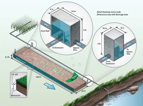
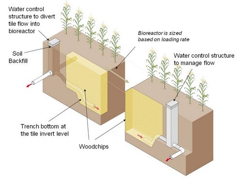
Illustration of how a denitrifying bioreactor fits in with drainage water management (DWM). Image by John Peterson.
Illustration of how a denitrifying bioreactor fits in with drainage water management
NOTE: This year, we’ll be highlighting some of 2015’s conservation practice innovations in a monthly series. NRCS supports science-based conservation by offering technical and financial assistance for nearly 170 conservation practice standards. As conservation science and technology advances, NRCS reevaluates each standard every five years and incorporates new advancements into conservation practice standards.
Walk to the edge of certain crop fields in Iowa and look down. You might not notice anything unusual, but just beneath the surface hordes of woodchip-dwelling microorganisms are busy removing excess nitrates from water before it leaves the field. By filtering nitrates, this organic gauntlet safeguards local streams and, eventually, the Gulf of Mexico.
Hungry microorganisms and woodchips are the key components of denitrifying bioreactors, a conservation practice that USDA’s Natural Resources Conservation Service (NRCS) made eligible for financial assistance last year with the publication of a Denitrifying Bioreactor conservation practice standard. Progressive farmers in the Midwest have been experimenting with bioreactors for about a decade, and NRCS has piloted the practice in a handful of states including Iowa, Minnesota and Illinois.
“We’re really excited about the potential to spread this technology across the Mississippi River Basin,” said Dr. Wayne Honeycutt, deputy chief for science and technology at NRCS. “When paired with nutrient management, cover crops and no-till practices, denitrifying bioreactors are a fantastic line of defense for subsurface nitrates.”
Water control structures (in the large white circles) route water running through tile lines into the denitrifying bioreactor
Water control structures (in the large white circles) route water running through tile lines into the denitrifying bioreactor, which lies underground at the edge of a field. Image by John Peterson.
A bioreactor is basically a buried trench filled with a carbon source – usually wood chips – installed at the edge of a field. Tile drains from the field carry excess water from the plant root zone, and divert a portion of the drainage water into the bioreactor. Microorganisms on the wood chips consume the nitrates in the water and expel it as nitrogen gas. Performance varies based on size, location, and avariety of other factors, but the average bioreactor can be expected to remove 35-50 percent of nitrates from the water flowing through it. Bioreactors have no adverse effects on crop production and do not restrict drainage.
In 2011, the Iowa Soybean Association was awarded a Conservation Innovation Grant from NRCS to increase farmer awareness and accelerate implementation of denitrifying bioreactors. Project leaders monitored and analyzed the performance of new and existing bioreactors, and explored ways to limit buildup of harmful contaminants in the woodchip pile.
“One thing we learned is that it’s important not to build bioreactors too large,” said Keegan Kult, environmental projects manager with the Iowa Soybeans Association. “If they’re too large, it becomes hard to control the flow of water through the bioreactor.”
The project also provided outreach and training to NRCS field staff and drainage contractors to build confidence and familiarity with the new practice. Kult said that the Iowa Soybean Association has been involved in the installation of 22 bioreactors in Iowa, and estimates that there are probably another 10-15 beyond that.
Installation costs of a bioreactor vary, but the average model costs $8,000-$12,000. NRCS, through the new conservation practice standard, may provide partial financial assistance for the cost of implementation. Nabbing Nitrates Before Water Leaves the Farm: Bioreactors, a short video by the Missouri & Mississippi Divide Resource Conservation and Development with support from NRCS, provides a nice overview of a bioreactor from start to finish.
NRCS promotes coordinated conservation practices that help producers avoid loss, and control and trap nutrients and sediment at the edge of farm fields. Denitrifying bioreactors hold great promise as a nutrient trap, reducing the flow of excess nitrates into local bodies of water, a significant water quality concern throughout the Mississippi River Basin.
Due to their potential for capturing nitrates, bioreactors are gaining popularity. Bioreactors are still a relatively new technology, however, and continued research and testing will lead to further refinement and performance improvement in the future.
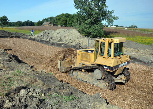
Installation of a denitrifying bioreactor
Installation of a denitrifying bioreactor. Nitrates beware. Photograph by Jason Johnson, NRCS Iowa.

Horned Lark

From the U.S. Fish and Wildlife Service, Mountain-Prairie Region:


A horned lark skips across the ground looking for food on Seedskadee NWR.

Friday, February 26, 2016

EPA Begins Reviews of Nine Site Cleanups this Year

News Release
U.S. Environmental Protection Agency
New England Regional Office
February 25, 2016
Contact: Emily Bender, (617) 918-1037
EPA Begins Reviews of Nine Site Cleanups this Year
BOSTON – EPA has begun reviewing site cleanups at nine Superfund Sites, including four Federal Facilities, across New England by performing required Five-Year Reviews of each site.  The reviews this year will include sites in Connecticut, Maine, Massachusetts, New Hampshire and Vermont.
Once a cleanup remedy or part of a remedy is in place at a hazardous waste site, it is important for EPA to regularly check on its progress to ensure the remedy is working properly to clean up the site. The primary purpose of the formal Five Year Review is to ensure continued protection of public health and the environment at the given Superfund Site.  In addition to extensive review of the remedy itself, the engineering and the overall functionality, EPA may also look at outside variables that could potentially affect the performance of the remedy, including things like redevelopment, climate change impacts and overall wear and tear.
EPA conducts evaluations every five years on completed clean up and remediation work performed at sites listed on the “National Priorities List” to determine if the implemented remedies at the sites continue to be protective of human health and the environment. Five year review evaluations identify any deficiencies to the previous work and, if called for, recommend action(s) necessary to address them.
The Superfund Sites where EPA will begin Five Year Reviews in Fiscal Year 2016 are below.  Please note, the Web link provided after each site provides detailed information on site status and past assessment and cleanup activity.  Once the Five Year Review is complete, a report of its findings will be posted to this website.  The web link also provides contact information for the EPA Project Manager and Community Involvement Coordinator at each site.  Community members and local officials are invited to contact EPA with any comments or concerns about a Superfund Site or the conclusions in the recent Five Year Review.
Connecticut
New London Submarine Base, New London, CT,
    Review of 24 Sites and 12 Operating Units
    http://www.epa.gov/superfund/newlondon
Maine
Eastern Surplus, Meddybemps, ME
    Review of Entire Site Remedy
    http://www.epa.gov/superfund/eastern
Massachusetts
Fort Devens-Sudbury Training Annex, Sudbury, MA
    Review of Area 7
    http://www.epa.gov/superfund/sudburyannex
Materials Technology Lab, Watertown, MA
    Review of Operable Units 1 and 3
    http://www.epa.gov/superfund/amtl
South Weymouth Naval Air Station, Weymouth, MA
    Review of Operable Unit (OU) 1 Site 1, OU2 Site 2, OU7 Site 7,
    http://www.epa.gov/superfund/sweymouth
New Hampshire
Coakley Landfill, North Hampton, NH
    Review of Operable Units 1 and 2
    www.epa.gov/superfund/coakley
Dover Municipal Landfill, Dover NH
    First Review of the entire remedy
    http://www.epa.gov/superfund/dover
Savage Municipal Landfill, Milford, NH
    Review of Operable Units 1, 2 and 3
    http://www.epa.gov/superfund/savage
Vermont
Pine Street Canal Superfund Site, Burlington, VT
    Review of Entire Site Remedy
    http://www.epa.gov/superfund/pinestreet
#  #  #
EPA Proposes Revisions to its Risk Management Program to Improve Chemical Process Safety and Further Protect Communities and First Responders

From USEPA:


CONTACT:
Julia P. Valentine (News media only)
valentine.julia@epa.gov
(202) 564-2663
(202) 564-4355

FOR IMMEDIATE RELEASE
February 25, 2016


EPA Proposes Revisions to its Risk Management Program to Improve Chemical Process Safety and Further Protect Communities and First Responders

WASHINGTON – The U.S. Environmental Protection Agency (EPA) is proposing to revise its Risk Management Program (RMP) regulations to improve chemical process safety, assist local emergency authorities in planning for and responding to accidents, and improve public awareness of chemical hazards at regulated sources.

“Chemicals are a necessary part of our everyday lives; however, as we have too often seen they can cause loss of life, injury and significant property damage,” said Mathy Stanislaus, EPA’s assistant administrator for the Office of Land and Emergency Management. “It is these dangers that we are working to prevent and minimize as we propose revisions to the RMP, such as improving our prevention program requirements, ensuring coordination with first responders, and ensuring that accident planning protects local communities that need to evacuate or shelter-in-place during an accident.”

While numerous chemical plants are operated safely, in the last 10 years more than 1,500 accidents were reported by RMP facilities.  These accidents are responsible for causing nearly 60 deaths, some 17,000 people being injured or seeking medical treatment, almost 500,000 people being evacuated or sheltered-in-place, and costing more than $2 billion in property damages.

The Accidental Release Prevention regulations under section 112(r) of the Clean Air Act (CAA), also known as the EPA RMP regulations, require covered facilities to develop and implement a risk management program.  The proposed revisions to EPA’s RMP regulations is a key action item under President Obama’s Executive Order (EO) 13650, Improving Chemical Facility Safety and Security.  EPA shares RMP information with state and local officials to help them plan for and prevent chemical accidents and releases.

This proposal is the result of a review undertaken to modernize the existing EPA RMP and information gathered from feedback obtained during listening sessions, Webinars, meetings with stakeholder groups, stakeholder conferences and public comments in response to EPA’s Request for Information.

The proposed amendments are intended to improve existing risk management plan requirements to enhance chemical safety at RMP facilities by:

•           Requiring the consideration of safer technologies and alternatives by including the assessment of Inherently Safer Technologies and Designs in the Process Hazard Assessment;
•           Requiring third party audits and root cause analysis to identify process safety improvements for accident prevention;
•           Enhancing  emergency planning and preparedness requirements to help ensure coordination between facilities and local communities;
•           Strengthening emergency response planning to help ensure emergency response capabilities are available to mitigate the effect of a chemical accident;
•           Improving the ability of LEPCs (Local Emergency Planning Committees) and local emergency response officials to better prepare for emergencies both individually and with one another; and
•           Improving access to information to help the public understand the risks at RMP facilities.

The RMP rule is just one aspect of EPA and the U.S. Government’s efforts to enhance the safety and security of chemical facilities throughout the nation. We continue our work under EO 13650 by assisting local communities in developing a local emergency contingency plan and facilitating a dialog between the community and chemical facilities on chemical accident prevention and preparedness.

The public will have 60 days from publication in the Federal Register to submit written comments online at www.regulations.gov (the portal for federal rulemaking), or by mail.

For more information about the proposed rule:
http://www.epa.gov/rmp/proposed-changes-risk-management-program-rmp-rule

Read Assistant Administrator Stanislaus’ blog:
http://blog.epa.gov/blog/2016/02/preparing-for-emergencies/

R033

EPA Announces Availability of $26 Million to Clean Up Diesel Engines Nationwide

From USEPA:


CONTACT: 
Christie St. Clair
stclair.christie@epa.gov
202-564-2880
FOR IMMEDIATE RELEASE: 
February 25, 2016
EPA Announces Availability of $26 Million to Clean Up Diesel Engines Nationwide
Preference given to fleets in areas with poor air quality
(Washington, D.C.) – The U.S. Environmental Protection Agency (EPA) today announced the availability of $26 million in grant funding to establish clean diesel projects aimed at reducing emissions from the nation's existing fleet of diesel engines. 
Diesel-powered engines move approximately 90 percent of the nation’s freight tonnage, and today nearly all highway freight trucks, locomotives, and commercial marine vessels are powered by diesel engines. 
EPA is soliciting proposals nationwide for projects that significantly reduce diesel emissions and exposure, especially from fleets operating in areas designated as having poor air quality.  Priority for funding will be given to projects that engage and benefit local communities and applicants that demonstrate their ability to promote and continue efforts to reduce emissions after the project has ended.  
Eligible applicants include regional, state, local or tribal agencies, or port authorities with jurisdiction over transportation or air quality.  Nonprofit organizations may apply if they provide pollution reduction or educational services to diesel fleet owners or have, as their principal purpose, the promotion of transportation or air quality. The applicants may apply until Tuesday, April 26, 2016.  
Under this competition, EPA anticipates awarding between 10 and 40 awards.  The top and bottom funding limits that will be considered for each proposal varies by region:
  • Region 1 (Connecticut, Maine, Massachusetts, New Hampshire, Rhode Island, Vermont):  EPA is requesting proposals between $100,000 and $800,000. 
  • Region 2 (New Jersey, New York, Puerto Rico, U.S. Virgin Islands): EPA is requesting proposals between $500,000 and $1,800,000.  
  • Region 3 (Delaware, District of Columbia, Maryland, Pennsylvania, Virginia, West Virginia): EPA is requesting proposals between $750,000 and $2,700,000. 
  • Region 4 (Alabama, Georgia, Florida, Kentucky, Mississippi, North Carolina, South Carolina, Tennessee EPA is requesting proposals between): EPA is requesting proposals between $300,000 and $1,900,000.  
  • Region 5 (Illinois, Indiana, Michigan, Minnesota, Ohio, Wisconsin): EPA is requesting proposals between $500,000 and $2,500,000.  
  • Region 6 (Arkansas, Louisiana, New Mexico, Oklahoma, Texas): EPA is requesting proposals between $400,000 and $2,700,000.  
  • Region 7 (Iowa, Kansas, Missouri, Nebraska): EPA is requesting proposals between $300,000 and $1,500,000.  
  • Region 8 (Colorado, Montana, North Dakota, South Dakota, Utah, Wyoming): EPA is requesting proposals between $300,000 and $1,500,000.  
  • Region 9 (Arizona, California, Hawaii, Nevada, American Samoa, Guam, Northern Mariana Islands): EPA is requesting proposals between $500,000 and $4,400,000.  
  • Region 10 (Alaska, Idaho, Oregon, Washington): EPA is requesting proposals between $300,000 and $800,000.  
Tribes are welcome to apply under this RFP, although EPA anticipates releasing a separate Request for Proposals for Tribal applicants during March.
Since the first year of the DERA program in 2008, EPA has awarded nearly 700 grants across the U.S. Many of these projects fund cleaner diesel engines that operate in economically disadvantaged communities whose residents suffer from higher-than-average instances of asthma, heart and lung disease.  
For more information and to access the Request for Proposals, visit http://www.epa.gov/cleandiesel/clean-diesel-national-grants.
For more information on the National Clean Diesel campaign, visit http://www.epa.gov/cleandiesel.
R032

Sunset at the Ninepipe National Wildlife Refuge

From the U.S. Fish and Wildlife Service, Mountain-Prairie Region:


Good night from the very beautiful Ninepipe National Wildlife Refuge in Montana. (Dave Fitzpatrick / #USFWS)

Invasive Annual Brome Grasses

From the U.S. Geological Survey (USGS):


This picture isn't as placid as it seems. Invasive annual brome grasses - the yellowish grasses in the landscape - are suppressing native prairie species at Scotts Bluff National Monument, Nebraska. (Credit: Amy Symstad, USGS)

Invasive plants such as annual brome grasses can overcome valuable native grasses in critical prairie grasslands. #USGS studies show that invasive annual brome grass abundance has doubled over the last two decades in parks in Wyoming and the Dakotas. The USGS studies annual brome grasses in the northern Great Plains to help resource managers tackle this destructive invasive species:http://on.doi.gov/1oEQyCD.

#science #invasivespecies #NISAW #brome#GreatPlains

Thursday, February 25, 2016

Oregon Conservation Groups Partner with USDA for Results

From the #USDA:


Ralph Duyck on the Tualatin River Watershed
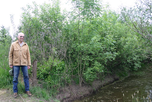
Ralph Duyck is one of 42 landowners who used the Conservation Reserve Enhancement Program (CREP) to protect the Tualatin River Watershed. With the initial goal of restoring fish habitat and cooling the stream, Duyck also noticed an increase in wildlife on his property.
A small group of conservation enthusiasts gathered at Ralph Duyck’s farm near Forest Grove, Oregon with a shared goal. They wanted to protect water quality and fish and wildlife habitat in and around the Tualatin River, an 83-mile tributary of the Willamette River that runs through Portland.
The group didn’t know how much interest they could attract or how much they could achieve—but that was 2005. Today, the Tualatin Basin Partners for Clean Water’s membership includes more than a dozen cities, counties, conservation districts, and environmental groups.
The group’s 10-year partnership, working to restore fish habitat and cool the stream, made USDA’s Conservation Reserve Enhancement Program (CREP) available to Oregon producers to protect the Tualatin River Watershed.
CREP targets high-priority conservation issues by forming a partnership between the federal government and state or tribal governments or other geopolitical bodies. Once a CREP agreement is formed, landowners can receive annual rental payments in exchange for removing environmentally sensitive land from production and implementing acceptable conservation practices.
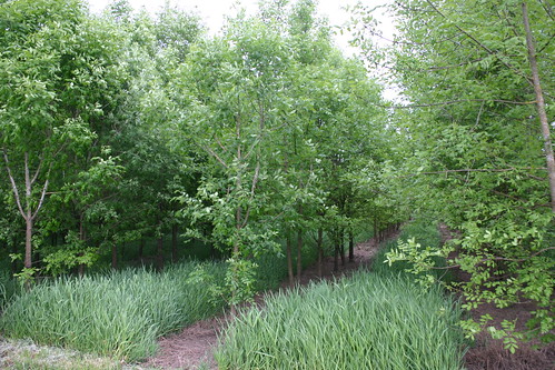
Now, 42 landowners have enrolled a total of 450 acres into CREP. They’re protecting more than 25 miles of stream bank by planting more than 50 different native plant species planted within the buffers. Invasive and weedy plants were removed and native vegetation was restored to improve stream habitat health and create shade to keep the water cool.
“The first year we had one project, the next year we had three and by the third year we had 27 projects,” said John McDonald, Chairperson of the Tualatin Soil and Water Conservation District. “The agricultural community bought into the project because of the multiple benefits.”
Conservation improvements helped stabilize banks, reduced erosion, slowed and filtered run-off, safeguarded ground and surface water, increased food and shelter for wildlife and pollinators and slowed the spread of invasive weeds.
As part of the program, around 25,000 trees and shrubs have been planted on the Duyck farm since 2005, many of which are Douglas Fir and Western Red Cedar.
Lyle Spiesschaert and his family also participate in CREP and have farmed the same land near Forest Grove Council Creek for almost 100 years.
“We have two miles of streams that flow into the Council Creek drainage area and we have planted all native species, trees and shrubs to help cool and filter the water and provide cover for wildlife, pollinators, bees, birds and insects,” said Spiesschaert. “Sometimes you know what is right, but it is hard to do it economically.  This program has allowed us to do the right thing for the environment.”
The Tualatin River Watershed partners participated in the “Tree for All” program which set a goal to plant 1 million trees in the area during 2015. USDA CREP projects contributed nearly 220,000 trees and the goal was surpassed by planting more than 1.2 million trees and shrubs in one planting year.
“This program is a beautiful working relationship,” said Duyck. “Wildlife is coming into the land because there is vegetation and trees for habitat.”
Tualatin River Watershed
USDA, conservation partners and landowners worked together to protect the Tualatin River Watershed by restoring fish habitat and cooling the stream.

Silvopasture: Adding a Little Forest to the Farm

From the #USDA:


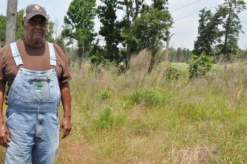
Hezekiah Gibson
Hezekiah and Francis Gibson’s non-profit organization, United Farmers USA works with NRCS staff to help other small farmers succeed through a wide range of outreach and technical assistance, educational programs and resources.
Lifelong farmer Hezekiah Gibson, and his wife Frances, farm 1,200 acres in Manning, South Carolina. They have been working with USDA’s Natural Resources Conservation Service (NRCS) for years to improve conservation on their farm.
In 2013, the couple’s non-profit organization, United Farmers USA―dedicated to helping small farmers succeed through a wide range of outreach and technical assistance, educational programs and resources―received an NRCS Conservation Innovation Grant (CIG). These grants help NRCS support public and private entities to accelerate technology transfer and adoption of promising technologies and approaches to address some of the Nation’s most pressing natural resource concerns.
Through their CIG project, the Gibsons have implemented a silvopasture demonstration area on their farm, and have educated other farmers on the benefits.
Silvopasture―the practice of combining forestry and the grazing of livestock―benefits timber, forage, and livestock production by allowing both practices on the same acreage, at the same time. It not only improves the appearance of the landowner’s property, it helps the livestock and environment too.
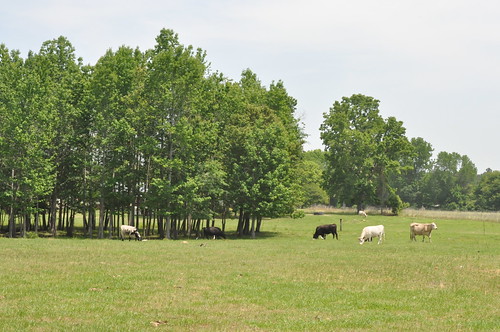
During the summer months, tree canopies provide shelter to livestock from heat and inclement weather. The Gibsons say silvopasture helps their livestock maintain body weight in the hotter months by continuing to graze during the day in the shade, as opposed to grazing only at night in open pasture when it’s cooler.
“Silvopasture is a win-win situation, as you can have value added attributes, such as baling and selling hay, or cutting trees for timber,” said Hezekiah.
Silvopasture is not new to the Gibsons. They have been using this conservation practice for years and have 120 acres in silvopasture. When managed properly silvopasture can help farming operations become more sustainable by increasing annual revenues and providing better use of forest lands.
They have also implemented several conservation practices on their farm, including fencing and cross-fencing 300 acres of pasture, which allows them to practice rotational grazing for their livestock. By using rotational grazing―moving cows to different pastures before it can be overgrazed―herd health is increased, soil erosion is reduced, and soil and forage health is greatly improved.
Through CIG funding, the Gibsons have hosted many two-hour classes, educational workshops, and demonstration tours for historically underserved landowners. Additional demonstration sites will be established in the Low country, Savannah, Pee Dee, and Coastal Plain areas to reach more farmers in USDA StrikeForce areas.
USDA StrikeForce teams operate in 880 counties in 21 states and Puerto Rico and provide opportunities for NRCS to work with underserved landowners to determine how best to leverage available financial assistance and address natural resource concerns—with an emphasis on historically underserved communities in rural counties that have consistently high poverty.
Farmers interested in learning more about Conservation Innovation Grants or land management practices should visit www.nrcs.usda.gov/GetStarted or a local USDA service center.
NOTE: For an interactive look at USDA’s work in conservation and forestry over the course of this Administration, visit http://medium.com/usda-results.
The Gibsons' field
The Gibsons have practiced silvopasture for years, and have found that it helps their livestock maintain their body weight by continuing to graze under trees during the day, rather than in open pasture at night when it’s cooler.

Nine-banded Armadillo

From Tulsa District, U.S. Army Corps of Engineers:


We spotted this critter digging for grub today at Twin Points Recreation Area on #Skiatook Lake in northeastern Oklahoma. 

According to Texas Parks and Wildlife, The Nine-banded Armadillo was originally native to South America, but now ranges as far north as Texas, Oklahoma, Kansas and Louisiana. Their distribution is often based on soil conditions, and they are not found where the soil is too hard to dig.

Similar in form to an anteater, the bony, scaled shell of the armadillo protects it from attacks by predators.

Armadillos are also insect-eating mammals and prolific diggers. They dig many burrows, as well as dig for food. The animal will not survive in areas where the soil is too hard to dig. Many other wildlife species use and benefit from abandoned armadillo burrows.

Although occasionally considered a nuisance by home owners, the armadillo's habit of digging up lawns is driven by its appetite for grubs, which can also harm lawns.

The armadillo eats insects and other invertebrates. They are skilled at digging for grubs and occasionally eat berries and bird eggs.

Click here for more information about Skiatook Lake and the surrounding area --> http://www.swt.usace.army.mil/Locations/TulsaDistrictLakes/Oklahoma/SkiatookLake/PertinentData.aspx

~ Tulsa District, U.S. Army Corps of Engineers

#Oklahoma #Texas #Kansas #Namethatcritter

Truffula Trees at Kilauea?

From the U.S. Geological Survey (USGS):


Truffula Trees at Kilauea? — 

Today on this day, for our #TBT,
we're sharing this photo of a Truffula tree?
In the year of '83 amongst the schlopp and the spatter
stood molds of tree trunks, whose lives did once matter.
The lava, it flowed, it hugged those tree trunks,
till nothing was left but burnt sticks and some stumps.
And much like Once-ler learned from the Lorax,
those leftover stalks provide us with facts.
The height of the flow that once passed thru
is the truth that we get from this gobbldy-goo.
And what of that tree that we can still see?
Perhaps, could it be, a Truffula tree?
Not likely, you see, as it came from the spatter
which bubbled and spurted until it went splatter
and popped on the top of the tree on a branch —
and there it cooled without a chance.

Thanks for bearing with us while we channeled our inner Dr. Seuss. This photo captures the initial fissure eruption that became Pu'u 'O'o — the current eruption of Kilauea.

The lava was once at the level of the tops of those "lava trees" (they're actually molds of tree trunks), which formed when lava flowed around the trees and cooled against the trunks. Often the trees burn from the contact with the lava, but the trunks remain in the tree molds until they burn completely or fall down. The great thing about this photo is that it shows us the high-stand of the lava level, and it likely flowed away after some initial surge. The skinny sticks in the middle of the molds are left over tree trunks. Of course, that's not really a Trufulla tree (from The Lorax book), but rather it was formed from spatter that got caught up in the branches and cooled.

#USGS #science #lava #volcano#ThrowBackThursday #Hawaii #poetry #Seuss

USDA Builds Conservation Partnerships to Restore Forests, Clean Water and Reduce Wildfire Risk

From the #USDA:


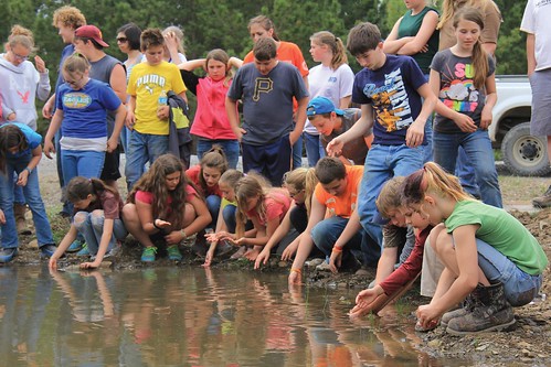
Green Bank Middle School students
The constructed wetlands on restored coal mine benches on the Greenbrier Ranger District of the Monongahela National Forest, not only provide habitat, but also serve as outdoor classrooms for groups that want to learn more about wetland ecology. These students are from the Green Bank Middle School (Pocahontas County, West Virginia). Photo credit: C. Barton (Green Forests Work).
Protecting our National Forests and surrounding lands against a myriad of threats is not an easy feat. That’s why joining forces with the right ally is a powerful strategy.
In 2014, U.S. Forest Service Chief Tom Tidwell and Natural Resource Conservation Service (NRCS) Chief Jason Weller formed a strategic alliance to establish the Joint Chiefs’ Landscape Restoration Partnership.
“We face a multitude of challenges in combating forest threats and the Forest Service can’t prevail alone,” said Tidwell. “The Joint Chiefs’ partnership provides a better way for us to work with local communities to reduce the risk of wildfires, ensure dependable local drinking water and improve wildlife habitat across the country.”
In just two years, the program has invested $67 million, supporting 28 partnerships improving the health and resiliency of ecosystems across 25 states. As a result of the joint partnership, states have already seen huge successes in forest restoration with results like reduced wildfire risk, improved water quality and invasive species control across large- and small-scale landscapes.
Entering its third year in 2016, the Chiefs recently announced a $7,000,000 investment in 11 new partnerships during the annual meeting of the Arkansas Association of Conservation Districts. It was also announced that the agencies will invest an additional $33 million to support 28 ongoing projects initiated in 2014 and 2015.
This partnership has a great track record of improving the health and resiliency of forest ecosystems where public and private lands meet. The partnership’s intent is to encourage cross-boundary restoration through collaboration between the Forest Service and NRCS, as well as state, local, non-governmental, tribal and individual landowner stakeholders.
Locally-lead projects emphasize activities that will reduce and mitigate wildfire threats to communities and landowners; protect water quality and supply for communities and industry; and improve habitat quality for at-risk species. Accomplishments are bountiful across all landscapes.
The Lake Superior Landscape Restoration project on the Chequamegon-Nicolet National Forest in Wisconsin is a good example. Over the past two years, this project has reduced accumulated underbrush that could fuel wildfires on 1,600 acres of public and private lands, along with roughly 100 acres of non-native invasive species eradication. Approximately 150 acres of private lands, 1,000 acres of public lands, and 46 stream miles are being worked on to enhance and expand critical habitat. A new public-private partnership has been formed to relocate sharp-tailed grouse into enhanced habitat created by the project.
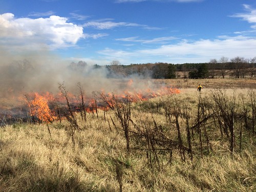
A prescribed burn on the Sylamore Ranger District
A prescribed burn on the Sylamore Ranger District helps accomplish glade and warm season grass restoration. The Western Arkansas Woodland Restoration project also uses mulching/mastication and chainsaws to complete restoration activities. Photo credit: Forest Service
Over the past two years the Western Arkansas Woodland Restoration Project partnership in the Ozark-St. Francis and Ouachita National Forests has created 71 miles of firebreaks on private lands, 15,236 acres of fuel treatments on public lands, restored more than 36,000 miles of stream habitat, treated roughly 60,000 acres for feral hog and non-native invasive species control, and provided technical assistance on nearly 41,406 acres helping to improve wildfire mitigation, water quality and wildlife habitat.
The West Virginia Restoration Venture on the Monongahela National Forest where the Red Spruce habitat is home to many threatened and sensitive species such as the Cheat Mountain Salamander and the Northern Flying Squirrel is another great example. Through this project, spruce planting has occurred over 393 acres of public lands and across 170 acres of private land. Roughly 65,000 seedlings have been released to improve critical wildlife habitat. Local and downstream water quality has also been improved by creating 205 wetlands and protecting 515 acres of riparian area.
By leveraging the resources of both agencies and involving private landowners and valued partners in these projects, the Joint Chiefs’ Landscape Restoration Partnership is helping to restore landscapes while working seamlessly across public and private lands.
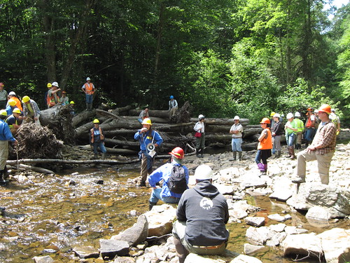
Students gathering to look at a one year old large woody material structure in the East Fork of the Greenbrier at Island Campground
Students gather to look at a one year old large woody material structure in the East Fork of the Greenbrier at Island Campground, Greenbrier Ranger District, West Virginia. These structures enhance stream conditions and provide habitat for aquatic organisms. Photo credit: Forest Service