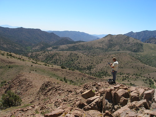
Brien Park, Nevada NRCS soil scientist, logs soil survey data into a computer at a soil survey site.
Brien Park, Nevada NRCS soil scientist, determines a soil profile. This information is available in the recently released soil survey.
Those curious about what’s below the water’s surface don snorkeling gear and immerse themselves into the depths of the ocean. But what about discovering what lurks below the earth’s surface, under topsoil, trees, shrubs, rocks and plants?
USDA’s Natural Resources Conservation Service, (NRCS) in Nevada is curious, too, and the agency’s soil scientists have finished unearthing what kind of soils lie beneath the surface in portions of central and eastern Nevada. Their findings are available to assist farmers, ranchers, land managers, homeowners or those just simply curious about what lies beneath.The survey covers 1,062,220 acres and includes three major land resource areas, which are based on geology, groupings of major plant communities and climate conditions. The survey provides soils and associated ecological site information for the Mount Moriah area, Schell Creek Range, Ward Mountain area, White Pine Range, and Grant Range of White Pine County and Quinn Range of Lincoln and Nye Counties. Work began in 2006 and was completed in fall 2013.
The survey used soil profiles that included color, texture and structure to identify characteristics that regularly support vegetative communities in those areas. Soils information, along with vegetation information, can be used to understand the types of crops that can be grown by farmers and ranchers, what seed should be used to replant the landscape post-fire or how to better manage the landscape for range, wildlife or wilderness.
The survey provides a key tool for land management agencies in making scientifically sound decisions when it comes to rangeland, forestland and wildlife management.
Soil surveys also provide valuable information for private land owners such as soil depth, rock and clay content of soil. This information is useful for gardening, constructing a home’s foundation or placing a septic system. The soil survey also provides information on soil characteristics that can be used to determine possible erosion and infiltration rates.
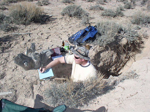
To determine what lies beneath, scientist first analyzed aerial images for similarities in elevation, geology, landform, aspect, slope and vegetation. They then went out into the field to collect soil profile information in representative areas. They dug holes up to five feet deep, which they were able to stand in while analyzing the area’s soil profile layers.
This allowed them to either confirm what they thought was beneath the surface or discover something unique. Soil profile and vegetation information is then analyzed to develop the final soil survey.
“I look at the soil layers to identify horizons based on color, texture, structure and rock fragments. Then I see if there are accumulations of things, such as calcium carbonate, salt or clays,” said Brien Park, NRCS soil scientist, who worked on the soil survey. “After I get my hands dirty, the next step is to use computers to correlate notes and information.”
During the winter, scientists entered the data into a national database, analyzed information and developed map units. The soil survey has been published on NRCS’ online tool.
The survey is a cooperative effort between the U.S. Forest Service and NRCS’ National Cooperative Soil Survey. NRCS has extensive national soils information, maps and data on 95 percent of counties nationwide.
No comments:
Post a Comment
Note: Only a member of this blog may post a comment.