Search This Blog

Thursday, August 11, 2016

Meet Connecticut Earth Team Volunteer: Misha Rosado

From the #USDA:


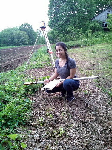
NRCS Earth Team Volunteer Misha Rosado
Misha Rosado’s superior skills in math, knowledge of surveying with the use of a transit and laser level, and her preference for working with adults has made her the quintessential engineering assistant.
At 5’1”, Misha Rosado is a tiny, 16-year-old powerhouse whose least favorite thing is to sit around with nothing to do. So, in addition to school and a part-time job, she donates 60-80 hours each year as an Earth Team Volunteer for USDA’s Natural Resources Conservation Service (NRCS).
You may wonder how this bright and very funny teen—whose interests include gymnastics and playing the flute—got involved in the agency. To her, the NRCS staff in Connecticut are like family. They practically are, seeing as how her dad has worked there for 32 years.
Civil Engineering Technician Michael Rosado (the person Misha doesn’t hesitate to name when asked who has been the most influential in her life) began teaching his daughter the ins and outs of his profession when she was very young. She also learned about NRCS by participating in Take our Daughters/Sons to Work Day each year. By the time she was 14, Misha was a full-fledged Earth Teamer. Her superior skills in math, knowledge of surveying with the use of a transit and laser level, and her preference for working with adults has made her the quintessential engineering assistant.
Misha thinks the work NRCS does is both important and fun—especially in the field. She says she loves being outside, as well as meeting landowners on the properties she’s visited.
When asked about a project that she feels was especially satisfying, she takes a minute to flip through the list she keeps in her head—recalling each one by landowner name and town. Her finger points straight up when she’s got the answer. It’s a property she and her dad had been to several times. During the waterway design survey, she and her transit stood ankle deep in muck that was a result of poor drainage in the field. On the final site visit, she got to see that same field looking pristine as a result of the grass-lined waterways that were installed to address excess water. Misha says there is a lot of satisfaction in being able to be a part of an undertaking like that.
It’s something she wishes she could share more of with her peers. She thinks young adults like her would love working with NRCS if they would just give it a try.
But Misha isn’t like every other teenager. She’s light years ahead, with her eye on the future. She dreams of being a criminal lawyer, helping innocent people in need. Until then, she tries not to sweat the small stuff in her life; she’d rather take the bumps and turn them into positive energy toward her volunteer work, and her paid job as an assistant coach at a gymnastics school.
Asked about her philosophy on life, Misha quotes Dr. Seuss:
Be who you are, and say what you feel,
Because those who mind don’t matter, and those who matter don’t mind.
They say you never get a second chance to make a first impression. When you’re Misha Rosado, you don’t have to worry. One chance is all you need. She’s a confident, caring young woman who loves to help people, and right now she’s doing just that—helping people help the land.
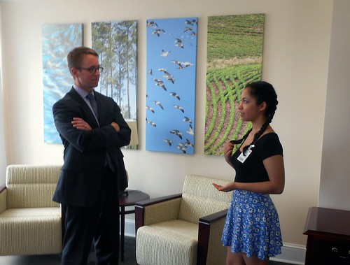
NRCS Earth Team Volunteer Misha Rosado with NRCS Chief Jason Weller
NRCS Earth Team Volunteer Misha Rosado meeting NRCS Chief Jason Weller.

Unauthorized Drones Near a Wildfire can Cost and Kill

From the #USDA:


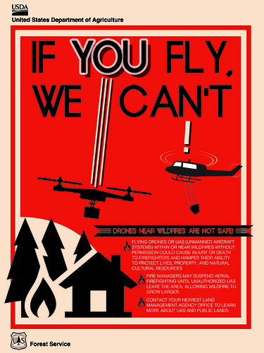
If You Fly, We Can't infographic
If You Fly, We Can't infographic. Design credit: Mary Horning, US Forest Service (Click to view a larger version)
Recreational drones or Unmanned Aircraft Systems sometimes called UAS have become increasingly popular in the past few years. While this is an interesting hobby and can allow you to get beautiful aerial photography, some activities pose a significant hazard.
The use of these drones to capture video footage of wildfires is one of those hazardous activities.
The US Forest Service wants you to know that unauthorized drone flights near a wildfire have the very real potential to cause serious injury or even death to firefighters and pilots who are in the air, as well as firefighters and public citizens on the ground. This is because aerial firefighting aircraft, such as airtankers and helicopters, fly at very low altitudes, the same as drones flown by the general public, creating an environment for mid-air collisions.
Adding to this disastrous mix of unauthorized drone flights and fire is the fact that firefighting aircraft typical fly in smoky, windy and turbulent conditions. Safety depends on knowing what other aircraft are operating in the airspace and where they are at all times. Consequently, their safety is compromised by the presence of a drone.
Suspending air operations because of drone use, which has happened several times already on major fires, could decrease the effectiveness of wildfire suppression operations. This year alone there have been at least 13 instances of unauthorized flights of drones over or near wildfires in at least seven states including California, Arizona, Nevada, Utah, Alaska, Minnesota, and Montana.
The effects of lost aircraft airtime could be compounded by potential flames moving into untreated terrain. This type of delay can allow wildfires to grow larger with the potential to threaten lives and property. Suspended air operations can also delay transportation of firefighters to different locations and add to costs of fighting the fire.
Those who fly drones without authorization over wildfires may be violating federal, state, or local laws, regulations, and ordinances, whether a Temporary Flight Restriction is in place or not.
All unauthorized drone flights over wildfires on National Forest System lands will be reported to theFederal Aviation Administration and law enforcement agencies. Individuals who have been determined to have endangered manned aircraft or people on the ground with a drone or interfered with wildfire suppression may be subject to civil penalties, including fines of up to $25,000, and potentially criminal prosecution.
So please be smart about where and when you choose to fly your drone.  If you fly, we can’t. And if we can’t we are unable to do our jobs to protect you, your family, or your neighbors from a wildfire.
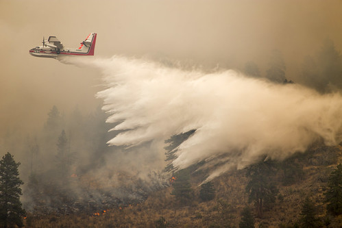
A firefighting aircraft
Firefighting aircraft, like drones, fly at low altitudes creating a high probability of collisions. Photo credit: US Forest Service

Tuesday, August 9, 2016

Illinois EPA Conducts Waste Tire Removal Action for Units of Local Government in Randolph County

Collections in Support of Mosquito Reduction Strategy


Illinois.gov - Illinois Government News Network (IGNN) - Search the News Results

The Science Behind Fire

From the #USDA:


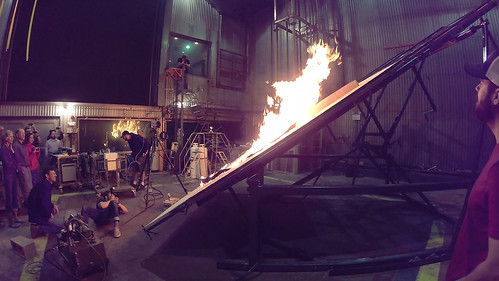
Researchers preparing for the next phase in examining physical fire processes
Researchers prepare for the next phase in examining physical fire processes by adding the effect of a slope. Photo credit: Mark Finney
In recent months, we have all become familiar with images in the media of wildland firefighters digging lines, air tankers dropping retardant and fire engines dispersing water. You may wonder “how do these firefighters know what it takes to fight fire?”
The short answer is: research.
Before a wildland firefighter sees his or her first fire, they are given the tools and training on how to fight fire and its behavior. The information passed onto them is not learned overnight but rather through years of research.
In the US Forest Service’s Missoula Fire Sciences Laboratory, in Montana, employees conduct research on flame, smoke, fuel types and how fire spreads. The lab has six different focus areas including one called the Physical Fire Processes which studies the fundamental physics of fire spread. Another one, Fuel Dynamics, works to make the process of fire behavior and its effects more accurately predictable, and the Smoke Emissions and Dispersion area’s focus is on a better understanding of smoke movement from fires and potential impacts. Other focus areas concentrate on the effects of fire on plants and the study of how a forest responds to fire disturbances and climate change.
Fire and firefighting have been around for centuries, so what else can we learn? The answer is a lot. In fact, we learn more each day.
For example, in 2015 the lab received an award for its research in buoyant flame dynamics in wildfire spread. As everyone knows, fire is hot, but the question that remained unanswered was “how is heat from a fire transferred to other fuels like pine needles so that it spreads?”
Our lab researchers discovered convection, or hot gasses bursting rapidly forward from the flames, which occurs by contact of air or fluid moving past an object, transferred fire.  Before this discovery, most scientists had considered radiation, the heat we feel from the sun or a fire, to be the key heat transfer mechanism in wildfires. The research showed that flame and hot gasses are forced into contact with new fuels because the rising motion of hot flames actually causes downward flow of cooler replacement air nearby. Thus flames form an alternating pattern of up and down motions along a fire front, and these motions cause the air to spin in the direction wind is moving.
After reading about the research our agency has been doing, you might have some ideas yourself, such as having the Forest Service test a new retardant (something that can be very time consuming and expensive). If you would like more information, contact the Missoula Technology and Development Center at 406-329-3900.

Thursday, August 4, 2016

U.S. Forest Service Celebrates 50th Anniversary of the National Historic Preservation Act

From the #USDA:


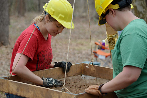
Passport in Time volunteers
Passport in Time volunteers use a wooden shaker to assist with excavations. Photo credit: Holly Krake
Signed by President Lyndon Johnson fifty years ago, the National Historic Preservation Act marked a fundamental shift in how Americans and the federal government regarded the role of historic preservation in modern life.
The U.S. Forest Service has a long history of protecting significant heritage resources, to share their values with the American people, and contribute relevant information and perspectives to natural resource management. Protecting these resources ensures that future generations have an opportunity to discover the human story etched on the landscapes of our national forests, grasslands and prairie.
A project that exemplifies this is an archaeological dig at a rare 400 year-old American Indian homestead site in Georgia. With each gentle scrape of the trowel, the underside of a large broken pottery vessel emerged from the dirt in a river valley on the Chattahoochee National Forest. Artful coils and swirls are stamped on the fired clay and a few feet to the left, the remains of a clay wall and burned wood help paint the story of what might have happened at this family farmstead 400 years ago.
The extended family that occupied this site were likely forerunners of the tribe we know today as the Cherokee. Each pottery piece helps us determine how these people lived in the early 1600s and why they were here.
Why they were here is an important question. As diseases, for which the native population had no resistance to, and warfare tactics, introduced by Spanish explorers, tore apart the region in the 1540s, native people coped however they could.
By approximately 1550, Native American mound building across the southeast had all but ceased, and it would not be until approximately 1670 that English explorers arrived and documented the Cherokee in northern Georgia. Now in the third year of excavations, more details from this site — radio-carbon dated to 1600-1615 — are being revealed.
“This year, we are able to confirm a square house roughly 600 square feet in size with a well-developed center hearth,” said Dean Wood, principal investigator from the firm Southern Research. “But questions still remain. Were they farmers? Refugees from regional warfare? What brought them to this valley?”
Working in small groups, local volunteers with the Passport in Time program are helping answer these questions. This spring, they helped recover more than 1,000 pottery sherds using large wooden shakers to separate the dirt from the artifacts. Several test pits were also excavated looking for pottery, stone tools and additional outbuildings used by the family.
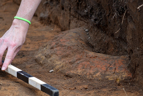
A clay hearth
A clay hearth is measured and catalogued during excavations. Photo credit: Holly Krake

Report: Maintaining Sagebrush-Covered Landscapes Keeps Water on the Land for Ranchers and Wildlife

From the #USDA:


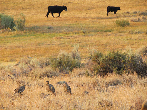
Sage grouse
Sage grouse are the iconic species of the West’s sagebrush sea. Photo by Tim Griffiths, NRCS.
Removing invading conifer trees improves the health of sagebrush ecosystems, providing better habitat for wildlife and better forage for livestock. And now, new science shows these efforts may also help improve late-season water availability, which is crucial for ecosystems in the arid West.
According to the Sage Grouse Initiative (SGI)’s newest Science to Solutions report – which summarized research from USDA’s Agricultural Research Service (ARS) – a sagebrush-dominated watershed holds water in snow drifts an average of nine days longer than one dominated by juniper trees.
Why is holding snow important for rangelands?
In the West, most precipitation comes in the form of snow. Having snow on the landscape longer gives water more time to slowly seep into the ground, providing more water in the soil at critical times for plants, sustaining wet meadow areas, and increasing late-season streamflow.
ARS researchers compared snow and streamflow data from sagebrush- versus juniper-dominated watersheds over the span of six years in the Owyhee Mountains of southwestern Idaho. Their goal was to better understand how juniper affects water availability. Working with physical data from four weather stations in the mountains, the researchers used iSnoball to model and estimate the amount of snow accumulated and how fast it melted in both juniper and sagebrush landscapes.
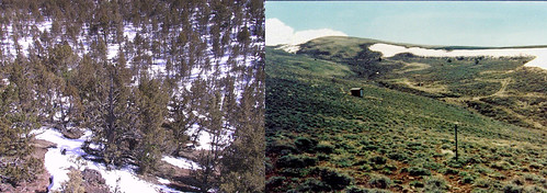
Stands of conifers evenly distributed snow compared with drifting snow in a treeless sagebrush landscape
Stands of conifers evenly distributed snow compared with drifting snow in a treeless sagebrush landscape. Photos courtesy of the Agricultural Research Service.
Why does snow melt slower in sagebrush?
A wide-open sagebrush landscape has higher wind speeds, causing snow to pile up deeper in different areas. This uneven distribution causes snow to melt at different rates and, in some areas, hold water for longer periods of time.
What are the benefits of snow in sagebrush?
Since parts of the sagebrush landscape hold water longer, the soil has more water available later in the season to grow “green groceries” – succulent grasses and wildflowers that make for high quality habitat and grazing lands. This ARS research also shows that snow-covered, sagebrush-dominated watersheds are better at turning limited precipitation into streamflow. Timing of snowmelt influences riparian and wet meadow areas that are critical for many species, including sage grouse, as the arid sagebrush ecosystem dries up during the summer.
What are we doing to help?
Over the last 150 years, the amount of conifers in the sagebrush sea has increased by up to 625 percent because of a combination of factors. This encroachment by junipers and other species has been detrimental to the ecosystem.
Through SGI, a partnership led by USDA’s Natural Resources Conservation Service (NRCS), ranchers and conservation partners are expanding sagebrush habitat by strategically removing conifers to preserve native grasses, wildflowers, and shrubs. This keeps the sagebrush sea intact and viable for wildlife and ranching operations. Research now confirms conifer removal benefits sage grouse and other sagebrush-dependent species. Plus, it makes rangelands more resilient to wildfire and more resistant to invasive weeds.
Conifer expansion is one of the five primary threats targeted by the agency’s Sage Grouse Initiative 2.0 investment strategy, which strategically directs conservation efforts where the returns on investment are highest.
Want to learn more?
Learn more about these findings by downloading this new report. This report is part of the Science to Solutions series offered through NRCS, SGI and the Lesser Prairie-Chicken Initiative.
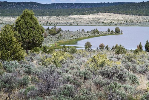
A wet meadow
Wet meadows are important for sage grouse in late summer. Photo courtesy of Jeremy Roberts.

Wednesday, August 3, 2016

EPA and USDA Pledge Actions to Support America’s Growing Water Quality Trading Markets

From the #USDA:


Cross-posted from the EPA Connect blog:
In September of 2015, EPA and USDA sponsored a three-day national workshop at the Robert B. Daugherty Water for Food Institute in Lincoln, Nebraska that brought together more than 200 experts and leaders representing the agricultural community, utilities, environmental NGOs, private investors, states, cities, and tribes to discuss how to expand the country’s small but growing water quality trading markets. Recently we released a report that summarizes the workshop’s key discussions and outlines new actions that we and others will take to further promote the use of market-based tools to advance water quality improvements.
Over the last decade, states and others have discovered that they can meet their water quality improvement goals through lower costs and greater flexibility by using a voluntary water quality trading program. Trading is based on the fact that sources in a watershed can face very different costs to control the same pollutant. Trading programs allow facilities facing higher pollution control costs (like a wastewater treatment plant or a municipality with a stormwater permit) to meet their regulatory obligations by purchasing lower cost environmentally equivalent (or superior) pollution reductions (or credits) from another source, including farms that use conservation practices to efficiently reduce the movement of nitrogen, phosphorus and sediment from their fields into local waterways. For example, Virginia’s nutrient trading program to offset stormwater phosphorous loads from new development has saved the Commonwealth more than $1 million in meeting state water quality goals while providing economic incentives to local agricultural producers to reduce soil erosion and runoff.
It’s a proven approach that creates new revenue streams for America’s farmers and ranchers while delivering significant environmental results.
While relatively few robust state and tribal water quality trading programs are in existence today, there is growing interest in markets as a tool for achieving water quality and ecosystem sustainability goals.
Our report summarizes the primary obstacles to market expansion and participants’ recommendations on how to simplify development of trading markets in their states.
It also captures the participants’ recommendations to the Administration on steps it can take to promote the use of environmental markets and water quality trading, which include:
  • Supporting a national dialogue series over the next three years, convened by the National Network On Water Quality Trading, to advance collective understanding of water quality program design, implementation, and operation across sectors and communities;
  • Increasing state awareness of water quality trading, through support of the Association of Clean Water Administrators working directly with state agencies;
  • Highlighting successful trading programs that have attracted private capital, or are otherwise financially sustainable;
  • Compiling a list of known, voluntary conservation program design frameworks that use market-like approaches;
  • Pursuing efforts to develop a national registry for water quality trading programs;
  • Forming a stakeholder group to develop a list of tools that meet the minimum requirements of the federal and state agencies that must verify trades Increase targeted stakeholder engagement; and,
  • Working with federal and state partners to actively engage in locations where increasing participation in market-based programs may result in more rapid nutrient decreases to address immediate problems such as harmful algal blooms.
These recommendations complement the USDA-EPA Water Quality Trading Roadmap andEnviroAtlas, products our agencies have jointly developed to simplify stakeholders’ efforts to establish their own trading markets.
States, communities, and farmers and ranchers who’ve championed this innovative idea are creating momentum for others to follow.  We look forward to supporting the expansion of these markets to help America more efficiently protect its water quality while supporting a vibrant agricultural economy in communities nationwide.