Search This Blog

Tuesday, September 29, 2015

New Perspectives on the Dynamics of Dry Lands

From the #USDA:


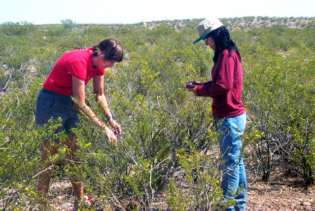
ARS ecologist Debra Peters (left) and New Mexico State University ecologist Jin Yao evaluate vegetation before estimating plant production at the Jornada Experimental Range.  Photo by Stacey Peters.
ARS ecologist Debra Peters (left) and New Mexico State University ecologist Jin Yao evaluate vegetation before estimating plant production at the Jornada Experimental Range. Photo by Stacey Peters.
Vast acreage of dry lands may evoke images of a desolate, scorched desert that is uninhabitable to humans. But the arid and semi-arid dry lands of about half of both the United States’ and the world’s land surfaces actually are complex ecosystems made up variously of grasses, shrubs, agriculture, and even urban dwellers. Now, ecological education about these complex dry lands has taken a step forward with the publication of a special issue of the journalFrontiers in Ecology and the Environment.
The special issue was organized by ecologist Debra Peters, USDA Senior Advisor for Earth Observations and Lead Principal Investigator of the Jornada Basin Long Term Ecological Research (LTER) Project. LTER is funded by the National Science Foundation (NSF) and based at the USDA-ARS Jornada Experimental Range (“Jornada”) in Las Cruces, New Mexico. Entitled “Emerging Perspectives and Shifting Paradigms in Water-Limited Systems,” the special journal issue includes seven scientific papers on new paradigms for dryland ecology and management.
In the special issue, the authors broaden the traditional framework for studying dry lands based on desertification to provide a comprehensive and improved approach for understanding, managing and predicting complex dryland dynamics. They provide new perspectives for the dynamics of how water and wind move material across dry lands in the context of historic environmental conditions, current climate extremes and changing patterns of land use.
The new framework can be used to assess dryland ecosystem services, inform land management decisions, and improve the ecological literacy of future generations living on dry lands.
The articles in the special issue were authored by ARS Long Term Agro-ecosystem Research (LTAR) Unit scientists at Jornada, including Peters and unit head Kris Havstad, and their colleagues at New Mexico State University, Arizona State University, the University of Arizona, the U.S. Geological Survey, the University of California at Los Angeles, and the Asombro Institute for Science Education.
The guest editorial was contributed by Ann Bartuska, USDA Deputy Under Secretary for Research, Education and Economics.
The special issue represents collaborations among partners at, and funding by, the USDA-ARS LTAR program, the NSF’s LTER Program, and New Mexico State University.

    

Southern Plains Climate Hub Helps Land Managers Build Resilience to Climate Variability

From the #USDA:


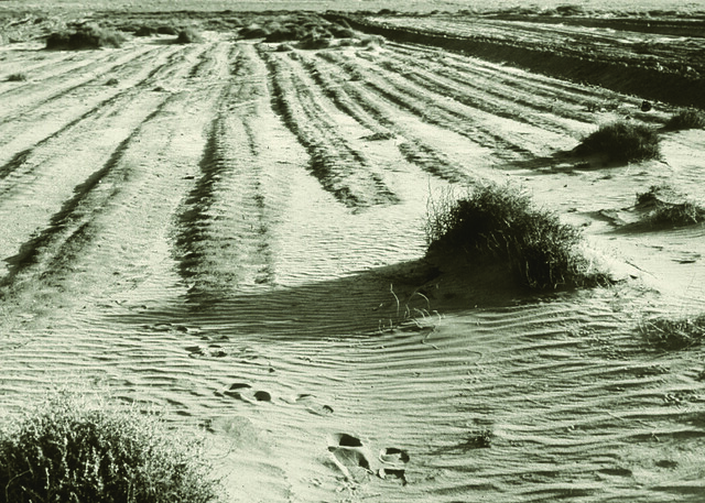
Wind-devastated farmland in Kansas during the Dust Bowl.
The U.S. Southern Plains states have always been known for their wild weather. Stories of the volatile climate of this region abound. Whether you’re talking about Pecos Bill roping a tornado in Texas, Dorothy being blown away by a twister to the Land of Oz, or the Dust Bowl in Oklahoma where “the wind comes sweeping down the plains,” all three of the Southern Plains states have a well-deserved reputation for extreme weather events. Never has this been more on display than in 2015. At the beginning of this year, the states of Kansas, Oklahoma, and Texas had suffered through four long years of an extreme drought greater even than those that ravaged the region during the Dust Bowl of the 1930’s. This extreme weather cost agriculture in the region well over $20 billion and put an incredible strain on the available water supplies of numerous communities. Then, in what seemed like the blink of an eye, in a repeat of what has happened so many times in the past, the extreme drought on the Southern Plains was finally broken by extreme rainfall.
May 2015 now ranks as the wettest month EVER in the history of Texas and Oklahoma. In Texas, the statewide average rainfall for May 2015 was 8.81 inches, shattering the old record of 6.66 inches. In Oklahoma, over 14.40 inches of rain fell in the same month, obliterating the old record of 10.75 inches. Kansas also saw heavy rain events, and while these storms did not set the over-all record in the Sunflower State, many Kansas communities rainfall totals for the month of May that were higher than anything they had recorded in over 100 years.
Extreme weather is nothing new on the Southern Plains. We have seen droughts and floods before. What is new is the level of intensity and volatility of these events and what’s really interesting is that this increase in extreme weather is playing right to script for what the experts say the effects of climate change will be in the region. When you talk about the effects of climate change in the Southern Plains you basically mean that the region’s crazy weather will just get crazier and with that increase in volatility and severity, the area’s agriculture industry and its rural communities will face an ever increasing set of challenges. The good news is that USDA, through its various agencies and partners, have several programs and initiatives to help agriculture producers and our rural areas adapt to the effects of climate change while also helping to address some of the phenomenon’s root causes. As part of our work on this overall effort, we at the USDA Southern Plains Climate Hub have worked to identify these programs and highlight their benefits in our region while identifying ways to build on their successes. We have helped facilitate research both through traditional USDA channels and through other agencies venues such as the Environmental Protection Agency National Risk Management Research Laboratory, to help identify the multiple environmental benefits USDA natural resource programs provide, including climate change mitigation and adaptation. We have worked together with our sister USDA agencies to facilitate demonstration farms both in partnership with cooperating farmers and ranchers on privately owned land and on traditional research farm settings, to help identify and highlight adaptation and mitigation strategies that fit the unique geographical, cultural and economic challenges of the various ecoregions of the Southern Plains while at the same time making bottom line, economic sense for the regions agriculture producers.
Numerous other USDA programs also continue to help address climate change and its effects on Rural America. Programs like those that provide farmers and ranchers protection through the Risk Management Agency (RMA); initiatives designed to save energy, reduce emissions and support rural infrastructure at Rural Development (RD); the research and development of new and improved farming and ranching practices by the Agricultural Research Service (ARS) and the National Institute of Food and Agriculture (NIFA) funded projects designed to help agriculture adapt to and mitigate the effects of climate change all have a role to play in helping our entire nation (not just rural areas) address the numerous natural resource challenges we will face in the future. The USDA Southern Plains Climate Hub will continue to work with all of these critical players throughout the Department of Agriculture to facilitate their good work, identify ways we can improve on existing USDA efforts, and help ensure that our farmers, ranchers and rural communities have the tools they need to address the challenge created by our changing climate.
We have to understand that the future will be more challenging for all of us as we struggle to deal with the effects climate change. The good news is that today USDA already has numerous tools at its disposal to help our nation adapt to these challenging times while at the same time reducing our impact on the climate as we move forward.


Minnesota Farmers Restore Coldwater Stream in Driftless Area

From the #USDA:


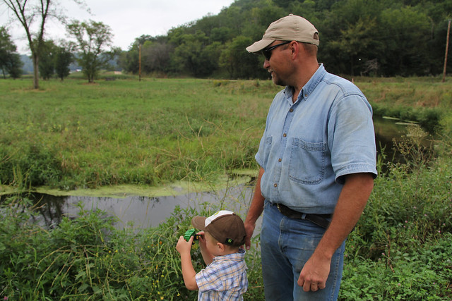
Ryan Pulley and his son look at Pine Creek, which flows through the land where he raises beef cattle in southeastern Minnesota. Photo: Julie MacSwain.
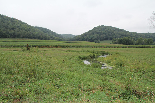
Pine Creek wanders through prairies and rocky bluffs, and forests and pastures, including the land where Ryan Pulley raises beef in southeastern Minnesota. Pine Creek is beautiful – fed by limestone springs and home to freshwater trout.
Coldwater streams like Pine Creek flow throughout the Driftless Area, a unique Midwestern landscape marked by its craggy limestone, sandstone valleys and steep hillsides. This terrain, which was bypassed by the glaciers, is blessed with one of the highest concentrations of limestone spring creeks in the world.
While beautiful, the land’s soil easily erodes. Heavy rains and flooding greatly degraded Pine Creek several years ago, causing its banks to erode and soil to wash into the stream.
USDA’s Natural Resources Conservation Service worked with five farmers in the region as well as conservation partners like Trout Unlimited, Lessard-Sams Outdoor Heritage Council and the Winona County Soil and Water Conservation District to restore a four-mile section of the stream, which eventually sends its waters to the Mississippi River.
Restoration work takes time. To restore the stream, NRCS worked with farmers to stabilize and smooth the sides of the creek. Then native shrubs and grasses were planted to hold the ground in place. This restoration work benefits Pulley because it safeguards his pastures against erosion. It also helps improve water quality, preventing sediment from polluting the shallow stream.

Pine Creek is one of hundreds of spring-fed streams in the Driftless Area, a unique landscape in Minnesota, Wisconsin, Iowa and Illinois. Photo: Julie MacSwain.
Coldwater streams provide critical trout habitat. High amounts of sediment can cover the bottom of streams, preventing trout from spawning. The spring water provides a near constant flow of cold water, and the water – enriched with limestone – provides essential minerals for aquatic insects, a common food of trout.
“Working on this project in Pine Creek has been challenging, but satisfying, as a NRCS district conservationist in Winona County,” NRCS’ Sue Glende said. “Knowing that I played a role in solving the bank erosion was gratifying.”
NRCS provides technical and financial assistance to farmers to help them implement conservation practices on their land. This assistance covers part of the cost. NRCS uses a variety of Farm Bill conservation programs to provide assistance as well as targeted initiatives to accelerate the delivery of the programs. NRCS launched the Driftless Area Landscape Conservation Initiative in 2013 to help restore and protect the unique landscape.
For more on technical and financial assistance available through conservation programs, visit nrcs.usda.gov/GetStarted or a local USDA service center.


Forest Service Funds Landmark Climate Change Study

From the #USDA:


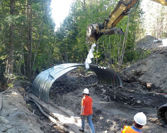
Workers replace a culvert with a larger one to accommodate higher water flows on the Colville National Forest (Photo Credit: USFS).
Preparing for the effects of climate change, the U.S. Forest Service has taken the lead in a new report that highlights actions taken by federal agencies to adapt to a changing climate.
“Some federal agen­cies are making good progress in climate change adaptation,” said University of Washington scientist and lead author Jessica Halofsky. “Most agencies have broad plans that describe approaches and priorities for climate change in general … but on-the-ground projects have been implemented slowly across the country.”
The report, Climate Change Adaptation in United States Federal Natural Resource Science and Management Agencies: A Synthesis was a response to direction from the Obama Administration for federal agencies to stress their accomplishments in adapting to climate change.
Published by the U.S. Global Change Research Program and funded by the Forest Service Climate Change Advisor’s Office, the report was written by Forest Service and University of Washington scientists.
One challenge in writing the report is that each agency has a different focus for adaptation. For example, the National Park Service focuses on protecting ecosystems, while the Fish and Wildlife Service is concerned about the effects of a warming climate on salmon. The Department of Defense has as a focus of protecting coastal facilities so they are not damaged by sea-level rise.
“We want to make sure that coordination is occurring in climate change programs across all federal agencies,” said Emily Seyller of the Global Change Research Program. “This new report gives us a baseline for coordinating responses to climate change in the years ahead.”
Although some have called for greater certainty about climate change effects before taking action, the report documents that at the local level, agency resource managers are moving forward with climate change assessments and adaptation strategies. For example, the Forest Service has already completed assessments for a third of its national forests.
“We’re drowning in data and scientific publications,” said Forest Service scientist Dave Peterson. “We need to take the information we have, assess the risk of climate change on natural resources, and manage that risk as part of agency business.”
The report’s authors are optimistic that federal agencies can make progress in climate change adaptation in the years ahead, but emphasize that implementation needs to be accelerated. “We’re not in crisis mode, but the clock is ticking as the climate continues to warm,” said Peterson. “If we don’t pick up the pace in responding, we may preclude options that would maintain the sustainability of resources on federal lands.”


#ClimateChange #GlobalWarming #forest #forestry

Unprecedented Collaboration to Save Sage-Grouse is the Largest Wildlife Conservation Effort in U.S.

From the #USDA:


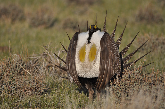
A male greater sage grouse struts at a lek, near Bridgeport, CA to attract a mate. Photo by Jeannie Stafford, U.S. Fish and Wildlife Service.
This is a cross-post from the White House Blog.
Summary: Thanks to the strong conservation efforts of various western leaders, the Greater Sage-Grouse no longer requires protection under the Endangered Species Act (ESA).
Today marks an historic win for conservation and communities in the West and for the United States. Thanks to unprecedented conservation cooperation across the western United States, the U.S. Fish and Wildlife Service announced earlier today that the charismatic rangeland bird – the greater sage-grouse – does not need to be protected under the Endangered Species Act (ESA). The greater sage-grouse conservation strategy comprises the largest landscape-level conservation effort in U.S. history and demonstrates that through strong Federal, state, and private collaboration, the ESA can be an effective and flexible tool in encouraging conservation and providing the certainty needed for sustainable economic development in our states and communities.
This success was only possible through close collaboration among western states, the Department of the Interior, USDA, and more than 1,100 ranchers across eleven states. The bipartisan leadership of many western governors, including Colorado Governor Hickenlooper, Wyoming Governor Mead, Nevada Governor Sandoval, and Montana Governor Bullock is a testament that when we work together, we can successfully conserve landscapes and help save species, while providing certainty to rural economies.
Roughly half of the sage grouse’s remaining habitat is found on public lands, primarily managed by the Bureau of Land Management and the U.S. Forest Service.  After taking into account extensive public and state input, Federal agencies also announced today the finalization of 98 resource management plans that are based on the best available science and address the primary threats to the sage-grouse and its habitat.  These plans and other actions by Federal and state agencies will also help reduce the threat of wildfire in western portions of the range. In total, these plans will put in place protections on nearly 70 million acres of important sage-grouse habitat.
These collective conservation efforts achieve more than protecting one species. The sagebrush habitat is shared with more than 350 other wildlife species, including world-class populations of mule deer, elk, pronghorn and golden eagles. They also provide sustainable development benefits that help local communities and the U.S. economy. More than 1,100 ranchers are voluntarily working with Federal and state agencies to conserve the greater sage-grouse. Since 2010, USDA has partnered with these landowners to conserve or restore 4.4 million acres of key habitat through programs that provide financial assistance for conservation, and hundreds of other properties are enrolled through similar state or Federal programs.
Today’s announcements mark an incredible milestone, proving that collaborative, science-based, forward-looking efforts can conserve an entire landscape. There’s no doubt that important work remains to ensure a bright future for the sage-grouse and the sagebrush habitat.  This includes implementing the state and Federal plans, as well as the comprehensive rangeland fire strategy. USDA has announced plans to spend another $211 million by the end of 2018 to help hundreds of ranchers conserve or restore more habitat, bringing the total to 8 million acres.  And Congress still needs to pass the Administration’s $45 million proposed increase in funds to help implement these public land management plans.  We are confident they will benefit both rural communities and the Western sagebrush landscape now and in the future.


#endangeredspecies #birds #conservation

Maryland Dairy Farmers Work to Improve the Health of Estuaries

From the #USDA:


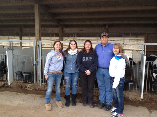
Dairy farmers Matt and Debbie Hoff with their daughters Courtney, Brook and Alicia
Dairy farmers Matt and Debbie Hoff with their daughters Courtney, Brook and Alicia. Photo credit: Genevieve Lister.
Producing high quality, nutritious milk may be a top priority for Coldsprings Farm, but it is not the farm’s only accomplishment. Nestled between the rolling acres and lush green meadows of New Windsor, Maryland, lies a showcase of a dairy farm where owners Matt and Debbie Hoff are working with USDA’s Natural Resources Conservation Service (NRCS) to reduce runoff of nutrients and sediment, leading to cleaner water downstream.
This is especially important, as Coldsprings Farm sits amid the Monocacy watershed, which eventually flows into the Chesapeake Bay.
At 64,000-square-miles and holding more than 150 rivers and streams, the Chesapeake Bay watershed is North America’s largest estuary. This week, NRCS marks National Estuaries Week by highlighting the stewardship of farmers like the Hoff’s, who voluntarily use conservation practices to improve water quality in estuaries downstream from their operation.
Coldsprings Farm is one of the largest family-owned dairy farms in Maryland, with a herd of 1,100 Holsteins, in addition to 2,200 acres of crops. Five generations of the Hoff family have farmed this land, using manure management practices, no-till, cover crops and riparian buffers to minimize runoff of nutrient and sediment while maintaining a productive farming operation.
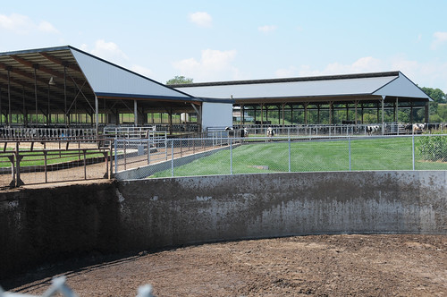
The Hoffs' manure storage structure
NRCS worked with the Hoff family to build a manure storage structure, which they use to contain manure that can be used as fertilizer when the time is best. Photo credit: Genevieve Lister.
With a large herd comes a lot of animal waste. To ensure the waste from their growing herd does not leave the farm and enter into local waterways, the Hoffs recently constructed a manure storage structure, with assistance from NRCS and the Environmental Quality Incentives Program (EQIP). The structure was built with a roof runoff system to ensure that clean water is kept clean and is directed to a suitable outlet. They also are using a practice called heavy use area protection, which helps keep soil in place in areas with a lot of cattle traffic.
“One of our biggest challenges is moving and storing manure,” Matt said. “We have enough storage now to hold close to 6 months of manure.”
With proper storage, the Hoff’s can use the manure as valuable fertilizer on their crops, applying it at the optimal rate and time. They use an aerator to incorporate the manure directly into the soil. This ensures the crops take up the nutrients with minimal leaching and runoff.
The conservation ethic runs deep in Matt and Debbie’s family, who started farming the land in 1869. Matt’s father, Marlin, travelled the countryside as a young boy and was inspired by the exemplary care some farmers took of their animals and land.
Marlin stopped tilling a few of his crop fields in the early 1970s, and by the early 1990s, the farm was 100 percent no-till. The Hoff’s were also early adopters of cover crops, growing small grains, legumes and grasses between their regular corn and soybean plantings. Leaving crop residue on the field and planting cover crops protects the soil and improves its structure, resulting in less runoff during storms.
“Cover crops really cut down on erosion loss – that’s the biggest reason we plant them,” said Matt. “We’ve also seen a big difference in the soil biology, and a big benefit in the next crop. Now, every acre that we combine off, we plant cover crops on.”
The Hoff’s planted grasses, trees and shrubs along the edges of their field to slow and absorb runoff. Buffer practices are critical to the Chesapeake Bay restoration effort.
“The edges are always a challenge on the field anyway, because of deer pressure and trees,” said Matt. “By putting in buffers, I don’t think we’ve removed a huge amount of productive ground and it helps keep nutrients on the field and out of the stream.”
Matt and Debbie Hoff are just one example of the many agricultural producers who are working with NRCS to install conservation practices that lead to cleaner water downstream, protecting valuable estuaries like the Chesapeake Bay.
Learn more about NRCS’ conservation efforts in the Chesapeake Bay watershed. For more on technical and financial assistance available through conservation programs, visit nrcs.usda.gov/GetStarted or a local USDA service center.


#ChesapeakeBay #conservation #dairy #farm #farmers #farming #Maryland #milk

#NRCS #water #waterquality #watersheds

It's Autumn in America

From the #USDA:


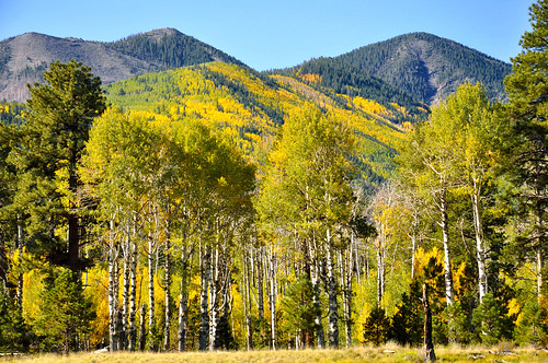
Trees in front of hills
With the Yonder app you can post pictures in real time.
One of the greatest natural events in the world is starting to change — change colors that is. The brilliant colors on the leaves of millions of trees are about to make you look up in awe and the U.S. Forest Service wants folks to get outside and experience it this Fall.
This year the Forest Service’s 2015 Fall Colors webpage has something unique to help those wanting to visit our national forests and grasslands experience the grace and glory of autumn just about everywhere in America. It’s a downloadable app called Yonder and it’s designed for sharing outdoors experiences on your smart phone for all the world to see.
With the Yonder app you can post pictures in real time, share amazing views of bursting fall colors with an avid community of outdoors enthusiasts. Being able to instantly pinpoint your location as you stare into a forest of bright reds, yellow and orange will be very helpful to those fellow leaf peepers who might not know where the best viewing spots are.
Additionally, Yonder allows you to add “experiences” by selecting categories like hiking, camping, biking or skiing to let others in similar experiences find you and vice versa. And, keeping track of what you and others are posting will be a lot easier using the hashtag #forestfallcolors.
We also have other useful tools to help plan your adventure to see colorful trees and beautiful wildflowers this autumn. So visit the Forest Service 2015 Fall Colors site often and don’t forget to share your pictures and outdoors experiences on Yonder!
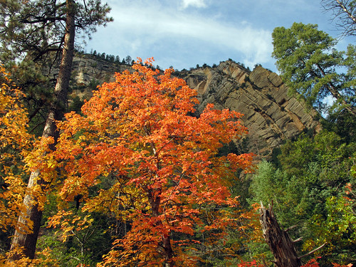
A red-yellow tree surrounded by green trees and in front of a cliff
Get out and experience the glory of autumn.